LGU officials study risk exposure maps
BALON DAGUPAN NEWS
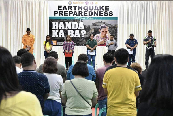
TO prepare them for possible disaster and risk hazards, local government officials of Dagupan led by Mayor Belen T. Fernandez, underwent a training-workshop conducted by the Department of Environment and Natural Resources (DENR) – Mines and Geosciences Bureau (MGB) at the City Hall on July 19.
The training, which is part of the Information, Education and Communication (IEC) Campaign for the MGB’s Vulnerability and Risk Assessment (VRA) project, was joined by city councilors and department heads and representatives of various offices in the city.
These include the City Disaster Risk Reduction and Management Office (CDRRMO), City Planning and Development Office (CPDO), City Engineering Office, City Social Welfare and Development Office (CSWDO), Public Alert and Response Monitoring Center (PARMC) and PNP Dagupan.
The VRA project is a continuation of the DENR’s National Geohazard Mapping and Assessment Program, with the MGB conducting 1:50,000-scale and 1:10,000-scale Flood and Landslide Susceptibility Mapping for cities and municipalities.
The Population, Built-Up Areas and Road Networks are considered three elements at risk during the assessment. Thus, risk exposure maps for the three elements were made to properly identify which barangays have the most number of people with potential of being affected by specific geohazards, and to identify the proper locations and the most appropriate alternate traffic routes and pre-positioning areas for recovery and relief operations.
The project is now seeking the optimized use of the 1:10,000-Scale Detailed Flood and Landslide Maps for local government units in their respective land-use and contingency planning by evaluating the existing vulnerability conditions within their areas.
Aside from studying the risk exposure maps, the participants were also able to determine the risk exposure of different barangays to various geohazard susceptibility ratings, re-evaluate the city’s Comprehensive Land Use Plan (CLUP), and develop appropriate contingency action plans based on the maps.
Mayor Fernandez, in her message, disclosed how the data gathered from the risk assessment can contribute greatly to the city’s disaster mitigation measures.
“Saving lives is one of the local government’s main responsibilities and understanding the risks (we could have in the city) is very important. These maps are vital because it would give us the data on how to implement our programs and help us work efficiently in saving the lives of our people.” said Fernandez.
Fernandez also added that the presented maps and data will be studied further and discussed in future Disaster Risk Reduction and Management meetings.
Meanwhile, MGB Supervising Geologist Vilma Vecino lauded Fernandez for personally participating in the workshop, saying this was “the first time that a mayor attended these trainings.”
“This just shows Mayor (Fernandez’s) dedication in prioritizing the safety of her constituents.” added Vecino. (Verdelle De Vera/CIO)
Share your Comments or Reactions
Powered by Facebook Comments